Our
walk on the Sunday took us to Goathland, which is a small village and
much of the land around is owned by the Duchy of Lancaster. The village
is also famous
for the filming of Heartbeat tv series based in the 60s. Lot of the
buildings were used in the series.
The
walk was about 7 miles and not led by me. It took us though woods and
across the moors before returning through a wooded area to Mallyan spout
waterfall
Our
walk on Saturday took us by bus to go north to Staithes and walk back
along the coast to Whitby. The route was easy to follow, just one path
and head south.
Staithes in time was a fishing village, but in time is more tourism
village now. It has a shelter harbour with two breakwaters’ and the
Roxby beck stream running though it. Couple of cafes and a pub on the
seafront and i would think most of the houses would
be second homes with just a few villages left.
From
Staithes we headed up hill along very muddy paths which slowed us down
and the first few miles took a lot longer. The wind was still strong
from the North
but it made good waves on the sea.
We
reached Runswick Bay another tourist trap in the summer. Cafes and
pretty painted boats on the side. Good sandy beach which the path went
along. Not sure if
you get through on high tide. Here the sea was foaming as it rushed in
and the large waves crashed in.
Further along we turned to head up Hob
Hole and here the path was a small river. First time we seen water
rushing down there. But that’s the summer we
had.
The next place we came to was Sandsend which was about 3km from
Whitby. Here the sea was crashing over the sea wall into the road. The
place is a mix of gift shops and cafes. Soon we were back at Whitby
threading are way though the back streets to head
back up the other side to the Abbey
We
just had a weekend in Whitby North Yorkshire and we stayed at the YHA
at the Abbey. Once we booked in we went for a run and as we got outside
it started raining.
Plus it was windy. The route in the picture from the smartphone did not
pick the gps until well in the run. In the end we did about 4km as the
wind on the front was gale force and the rain turned to sleet, but we
did enjoy the quick run or slow when in the
head wind. It was nice running the back street and alley ways that we
found behind the main seafront shops. We were running past these small
houses that must have been just two rooms in all and in the old days
could have been fisherman’s houses.
The alarm went off. We miss the last four Saturdays. It was parkrun time and they only downside was I was full of cold. So Helen was doing the running and I was taking photos. I could have ran but I guess I would have not felt any better.
So a lovely day again to run around Heaton park in full colour of golden autumn leaves. Helen set off and I wander taking photos. Always surprise me that 10 mins before the start there just a few runners and then 5 mins later there well over 250 runners just appear.
Helen arrives in at 32.35 and she thought she did a lot worst then that. She was happy at the time and I was happy later in Sainsbury Cafe having my bacon bap
One of the things we took besides our walking gear, was our running shoes. So we not up at the big distances with running compare to the walking we do, but it would be nice to run in the warm weather. The plan was to do about 3 or 4 runs but in the end we only did 2. We nearly did 3 but after the gorge walk we missed the ferry by 5 mins and we had to sit in a bar for 3 hours until the next one. Plus time we got back to hotel we had to pack as we were leaving the next day and we had very wet walking boots to dry out for the plane the next day.
Both runs was along the bay of the town. The second one we just ran down different streets to have a look around the town and up roads to see what was up there. Good way to see the town. There is a lot of people use the bay to run, as we could watch them pass our hotel.
Second Run. Green Start should have been where red mark is. Gps did not pick up
We booked a guided walk to do the gorge for 49 euros and we were
glad we did as the guide was good. He knew the best route down and which side
of the arrows to follow and get down. We should have been on this walk on the
Monday but it was cancelled due to the rain. We were told by the guide that
some did the walk any way and they had to swim out at the end due to the
flooding.
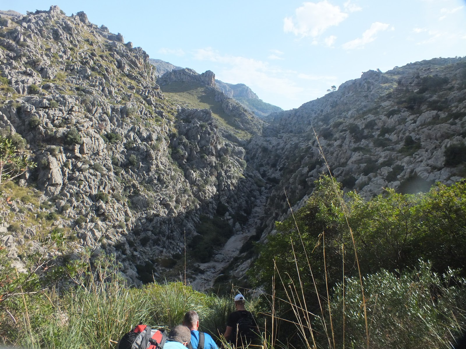
The Torrent de Pareis is Europe’s second largest gorge and
is Mallorca most challenging and popular walk. We met at the outdoor shop in
Port De Soller and met our guide Justin for the day. His instructions through
the day were excellent and he made you at ease on the hard bits. The group was
made up of Germans and Swedes. The Swedish lads were a little late at arriving
which made us late to start. This had a knock on effect at the end when we
missed the ferry.
Footwear we had boots on, where some had trainers or trail
shoes. Justin said boots were better if you had weak ankles, as your foot will
get stuck in between the rocks on the way down.
The first 1 ½ hour of the walk leads you down from the road
following a good path that zig zags down into the gorge bottom. On route we are
shown a building in the distance and explained it was a police station years
back. This was due to the smuggling route that the gorge was used for, for
drugs and cigs. Lot of money was made and the main leader now owns one of the
main banks on the island.Plus he now
owns all the land around the gorge plus a lot around the island.Even the old police station he owns now.
Once in the gorge bottom the next few hours to the sea got a
little tougher. The ground you walking on is the river bed so you are stepping
over boulders or climbing over them. Taking big strides or getting your ankle
stuck between the rocks. Sliding down steep rock using your boots as a brake
and using a rope to get down. Going through holes in the rock and dropping
down. Stepping into waist high water and wading through.This is a good work out walk where you will
know you have done a good walk by the end. The rocks and boulders are all worn
smooth as glass from water running down the gorge and the many people who’ve
done the route, making problems out of parts that would otherwise be quite
simple.
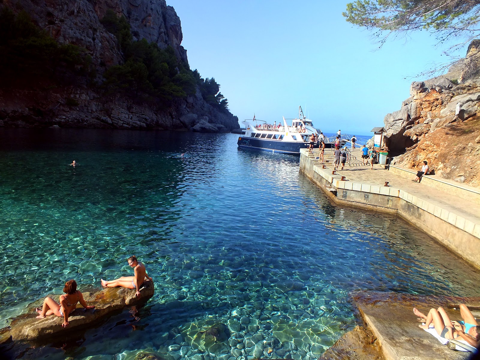
Once at the end you will meet the sea and you will see more
people as you near the end.You follow
the path though some tunnels to another small beach area. This is where you
pick the ferry back to Port De Soller. There is a bus you can catch back up to
the road but there is only one in the afternoon at about 2.30pm. Miss it and
it’s a long walk back up the road. Having just missed one ferry, we had an hour
and a half to wait for the next one, so enjoyed a few beers in one of the
places there, then took our boots off and sat in the sun to try and dry off a
bit.
It’s a cracking walk to do and we were glad that we
booked a guide to do it. Follow the links for more photos and check the videos
out on this blog site. Details of who we used can be found at the end of this
blog.
Today we had to get the 9am bus from Port de Sollerwhich would take us up to Cuban reservoir.
Anyone planning to do this walk be ready for a mass push for the bus door. You
will find no queue or what queue was there is no longer. It seems the Germans
like pushing in and unfortunately not everyone there managed to get on the bus
due to lack of space.
The journey up the main road is about 35 mins and winds it
way around the mountain side. Sometime you be looking out of the window down
sheer drops as the bus swings in way round the bends.The bus stops at a large lay bay and nearly ¾ of the bus gets
off.At this point I realise I forgot
my water bottle. It’s a nice hot day and no shops or bars at the stop.
You have a choice of two ways round the reservoir. The right
side is shorter then the left. We choose the left as we are going to leave the
path and head up onto the ridge and do a couple of tops. So we head down a good
service track road until we come to the dam where we turn left and leave
everyone else to head down. We head up a stoney path to a small coll where we
have great views to a valley.. Pity the other walkers don’t even come up to
have a look at what’s on the other side. We follow the path but without the
book we could easily miss the turning that we want. The markings are faint. We
are now following cairns up the mountain which is not easy in the sun. As they
light grey they just blend in and plus they are small cairns. Few times we did
go wrong or the cairns stopped and we had to back track. Once we get further on
we turn and look back at some great views and other paths we can see on the far
hills. Another walk for another day.
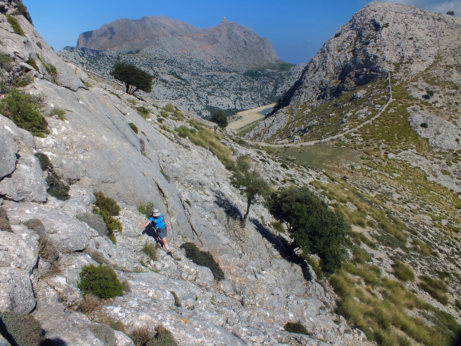
The book says look out for a donkey trail path which we find
and this is easy to follow as it zigzags up the mountain. Nearing the top the
paths stops and we back onto cairns which are all over the place. So we know
where the ridge should be so we make a line for that. Soon we are on the top
and looking down onto the reservoir and the path that every one took. Think it
took us about hour half to get to the top. All round is good views. You can see
the RAF post across the way and the other way is the ridge we are going to do.
We check the map to see which point we will come of the ridge as we still got
long way to get down. The main path that everybody took is about 3 to 4 hours
and we are about 2 hours to add on to that.
After lunch on top we carry long the ridge and do another
two tops. One is a small scramble up the rocks. If the cloud is down you would
need to be careful following the route as sometime there was not a path on the
ground.. After our final summit we take the path down and start to meet loads
of people coming off the other summit which we did not want to do. Seems everybody
does that one.So we now rejoined the
main path from the reservoir and its starts as a good forest track which keeps
us cool. We come across very large boulder on the path which at some point must
have rolled in from some where. As the paths heads down it then changes to a
stone path. Small stones set like cobbles. This zig zags all the way down to
the valey floor and we are about 2 hours from the bottom. All round you can see
the olive terraces that must have been built 100 of years ago. Now look not in use.
But amazing how they are built. We passed a few people on the way and a few are
also heading up. Its very hot as well now and we are down to the last drop of
water, but further down we came to a cross a tap with big metal mug on a chain.
So we took the chance of drinking the water and it was nice and cold.
We arrive in the village of Binarar where we have a cold
beer before moving on to Soller where we have a Orange Soller ice cream.Fresh orange in a glass with orange ice
cream and cream. Very refreshing. We then get a taxi back to Port de Soller for
8 euros.
Overall a good walk and we were glad we took the
detour to do the ridge instead of following the crowd.
Today we going to do the Three Village walk and have a look round the village life. From Port de Soller we take the road to Soller following the tram line. We follow the narrow streets into Soller, stepping back on the narrow pavements as the cars come past.
We arrive in the main square which is bustling with people and lined with cafe bars. In the centre is a water fountain and on one side is the main church of Soller with the tram line running at the side to the main railway station. We have a look inside the church and my first thought is how dark it is inside. Just the light from the windows coming in lighting up the gold leaf alter.
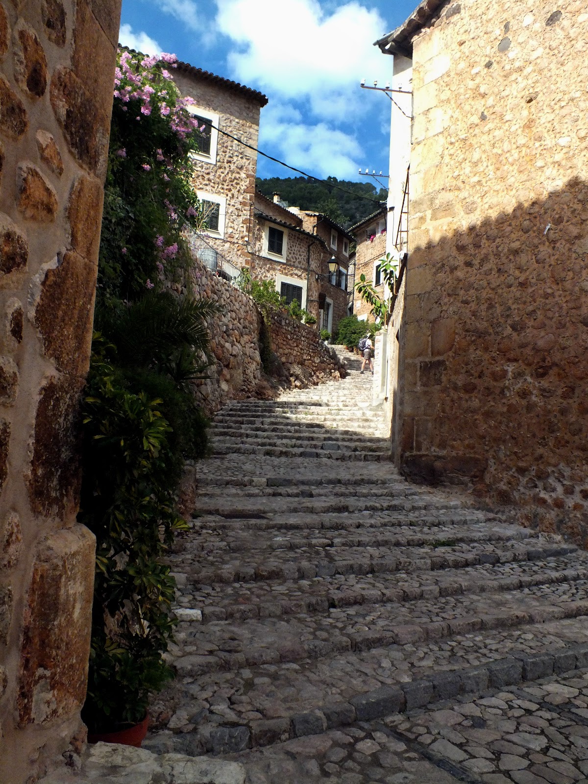
We leave Soller square and walk up one of the main shopping street with a mix range of shops. We then turn out of Soller and find a path that leads us to Binibassi. All along we are passing many orange and lemon trees. The path carries on up, passing olive terraces to the village of Fornalutx. This is known as one of the best Mallorca traditional villages. We enter the main square where narrow cobble streets lead up and down and smaller one cross them. Each of the narrow streets or alley ways are lined with large terracotta plant pots.
We have lunch in a cafe in the main square and watch people go past. We also see our first Orange Soller being made. A tall glass filled with orange ice cream, fresh squeezed orange juice and topped off with fresh cream and chocolate.
After lunch we wander more around the alley ways and look into the court yards of the buildings. Lovely little village where you can just wander and take many photos. We now head out of the village and down the valley to Biniraix which we pass through again later in the week. There is only one cafe bar which is busy with walkers from doing the Cuban walk.
As the mountains still had low cloud hanging around, our walk today was going to go along the coast to Cala de Deia. We are following a route from the guide book, but with a few changes to the route.
From the hotel we turned left and headed up the winding road to the light house at Cap Gros. Here you will also find a Refuge hut used mainly by the trekkers doing the GR221. The light house had a board up about its history and life of the people who worked there plus the normal info about when in the heat of the moment it took hours to get a replacement light.
From the lighthouse we took the GR221 path which was very rough and muddy. This took us to a better track and then onto the main road. This was one change to the route we took, most would follow the book but we took the path down to the coast, doing it in reverse. First it was road/track passing some nice homes on the way down. Some looked like second or holiday homes. At the bottom we missed the path, but this was down to a very faint red dot we missed. The path now followed the coast towards Cala de Deia. It was not easy to follow as there were many false paths leading off and fallen trees in the way. We had to climb over or go under them and it was at times back breaking but it was a great path to walk with great views. In the end we came round the headland to see Cala de Deia below us, a small cove with two cafes, one on the beach and one built on the rocks.
We headed for the cafe built on the rocks, where we had a beer. The menu for the food is more full meals then snack food. While we were there we had a camera crew filming collection of small gold boxes, which look like for an advert. So strange place to do an advert, and four crew with walkie talkies and ear pieces. Bit over the top and then another two guys coming running in with another camera crew in hot pursuit. It turns out it was some TV treasure hunt show and the boxes are musical boxes with clues. We watch for a while but move on when the camera men are stepping onto our table to get better shots and jumping around.
We head up the road in the direction of the village of Daia to take the GR221 path back to Soller. The path is a good track and well maintained and passes many orange and lemon groves. The route finding is a lot easier along the cobble paths. We pass a very large building which we think was a bed and breakfast place, but it was a huge building. We stopped at the next hotel as the sign said beer and it was hot. This is where we changed the route again to get to Soller. We enjoyed the beer on the terrace looking across the valley. The hotel was once a monastery and the food looked good. So we followed the track down the valley and missed our turning as the sign was behind us. We did not go far wrong as we turned to far south. We retraced our steps to find the path back to Port de Soller


